Clixsense

Saturday, April 30, 2016

World’s First Computer Rebuilt, Rebooted After 2,000 Years

A BRITISH MUSEUM curator has built a working replica of a 2,000-year-old Greek machine that has been called the world’s first computer.
A dictionary-size assemblage of 37 interlocking dials crafted with the precision and complexity of a 19th-century Swiss clock, the Antikythera mechanism was used for modeling and predicting the movements of the heavenly bodies as well as the dates and locations of upcoming Olympic games.
The original 81 shards of the Antikythera were recovered from under the sea (near the Greek island of Antikythera) in 1902, rusted and clumped together in a nearly indecipherable mass. Scientists dated it to 150 B.C. Such craftsmanship wouldn’t be seen for another 1,000 years — but its purpose was a mystery for decades.
Many scientists have worked since the 1950s to piece together the story, with the help of some very sophisticated imaging technology in recent years, including X-ray and gamma-ray imaging and 3-D computer modeling.
Now, though, it has been rebuilt. As is almost always the way with these things, it was an amateur who cracked it. Michael Wright, a former curator at the Science Museum in London, has built a replica of the Antikythera, which works perfectly.
In the video from New Scientist below, Wright shows how the machine works.
In short, Antikythera’s user interface is deceptively simple, operated by a simple knob on the side. This conceals the intricacy within, amounting to a complex mathematical model, tracking the movements of planetary bodies and incorporating a series of submechanisms to account for the eccentricities of their rotation.
A dial on the faceplace featured the Greek zodiac and an
Egyptian calendar; pointers showed the location of the moon and the five planets known at the time. On the machine’s back, an upper dial shows a 19-year calendar (matching the solunar cycle) and the timing of upcoming Olympic games. A lower dial shows a 76-year cycle (when the Olympic and solunar cycles coincide) and indicates the months in which lunar and solar eclipses can be expected.
According to New Scientist, this is the first working model of the Antikythera computer to include all of the device’s known features. And, like the original machine, it has been built of recycled metal plates. That’s right: The Antikythera mechanism is not only the world’s oldest computer, it’s also the world’s first green computer

The death of Genghis Khan

Genghis Khan, the Mongol leader who forged an empire stretching from the east coast of China west to the Aral Sea, dies in camp during a campaign against the Chinese kingdom of Xi Xia. The great Khan, who was over 60 and in failing health, may have succumbed to injuries incurred during a fall from a horse in the previous year.
Genghis Khan was born as Temujin around 1162. His father, a minor Mongol chieftain, died when Temujin was in his early teens. Temujin succeeded him, but the tribe would not obey so young a chief. Temporarily abandoned, Temujin’s family was left to fend for themselves in the wilderness of the Steppes.
By his late teens, Temujin had grown into a feared warrior and charismatic figure who began gathering followers and forging alliances with other Mongol leaders. After his wife was kidnapped by a rival tribe, Temujin organized a military force to defeat the tribe. Successful, he then turned against other clans and tribes and set out to unite the Mongols by force. Many warriors voluntarily came to his side, but those who did not were defeated and then offered the choice of obedience or death. The nobility of conquered tribes were generally executed. By 1206, Temujin was the leader of a great Mongol confederation and was granted the titleGenghis Khan, translated as “Oceanic Ruler” or “Universal Ruler.”
Khan promulgated a code of conduct and organized his armies on a system of 10: 10 men to a squad, 10 squads to a company, 10 companies to a regiment, and 10 regiments to a “Tumen,” a fearful military unit made up of 10,000 cavalrymen. Because of their nomadic nature, the Mongols were able to breed far more horses than sedentary civilizations, which could not afford to sacrifice farmland for large breeding pastures. All of Khan’s warriors were mounted, and half of any given army was made up of armored soldiers wielding swords and lances. Light cavalry archers filled most of the remaining ranks. Khan’s family and other trusted clan members led these highly mobile armies, and by 1209 the Mongols were on the move against China.
Using an extensive network of spies and scouts, Khan detected a weakness in his enemies’ defenses and then attacked the point with as many as 250,000 cavalrymen at once. When attacking large cities, the Mongols used sophisticated sieging equipment such as catapults and mangonels and even diverted rivers to flood out the enemy. Most armies and cities crumbled under the overwhelming show of force, and the massacres that followed a Mongol victory eliminated thoughts of further resistance. Those who survived–and millions did not–were granted religious freedom and protection within the rapidly growing Mongol empire. By 1227, Khan had conquered much of Central Asia and made incursions into Eastern Europe, Persia, and India. His great empire stretched from central Russia down to the Aral Sea in the west, and from northern China down to Beijing in the east.
On August 18, 1227, while putting down a revolt in the kingdom of Xi Xia, Genghis Khan died. On his deathbed, he ordered that Xi Xia be wiped from the face of the earth. Obedient as always, Khan’s successors leveled whole cities and towns, killing or enslaving all their inhabitants. Obeying his order to keep his death secret, Genghis’ heirs slaughtered anyone who set eyes on his funeral procession making its way back to Karakorum, the capital of the Mongol empire. Still bringing death as he had in life, many were killed before his corpse was buried in an unmarked grave. His final resting place remains a mystery.
The Mongol empire continued to grow after Genghis Khan’s death, eventually encompassing most of inhabitable Eurasia. The empire disintegrated in the 14th century, but the rulers of many Asian states claimed descendant from Genghis Khan and his captains.

Who Built the Pyramids?


THE PYRAMIDS AND THE GREAT SPHINX rise inexplicably from the desert at Giza, relics of a vanished culture. They dwarf the approaching sprawl of modern Cairo, a city of 16 million. The largest pyramid, built for the Pharaoh Khufu around 2530 B.C. and intended to last an eternity, was until early in the twentieth century the biggest building on the planet. To raise it, laborers moved into position six and a half million tons of stone—some in blocks as large as nine tons—with nothing but wood and rope. During the last 4,500 years, the pyramids have drawn every kind of admiration and interest, ranging in ancient times from religious worship to grave robbery, and, in the modern era, from New-Age claims for healing "pyramid power" to pseudoscientific searches by "fantastic archaeologists" seeking hidden chambers or signs of alien visitations to Earth. As feats of engineering or testaments to the decades-long labor of tens of thousands, they have awed even the most sober observers.

The question of who labored to build them, and why, has long been part of their fascination. Rooted firmly in the popular imagination is the idea that the pyramids were built by slaves serving a merciless pharaoh. This notion of a vast slave class in Egypt originated in Judeo-Christian tradition and has been popularized by Hollywood productions like Cecil B. De Mille's The Ten Commandments, in which a captive people labor in the scorching sun beneath the whips of pharaoh's overseers. But graffiti from inside the Giza monuments themselves have long suggested something very different.
Until recently, however, the fabulous art and gold treasures of pharaohs like Tutankhamen have overshadowed the efforts of scientific archaeologists to understand how human forces—perhaps all levels of Egyptian society—were mobilized to enable the construction of the pyramids. Now, drawing on diverse strands of evidence, from geological history to analysis of living arrangements, bread-making technology, and animal remains, Egyptologist Mark Lehner, an associate of Harvard's Semitic Museum, is beginning to fashion an answer. He has found the city of the pyramid builders. They were not slaves.

"I FIRST WENT TO EGYPT as a year-abroad student in 1973," he says, "...and ended up staying for 13 years." His way was paid by a foundation that believed a hall of records would be found beneath the paws of the Sphinx. Young Lehner, a minister's son from North Dakota, hoped to discover if that was true. But the more time he spent actually studying the Sphinx, the more he became convinced that the quest was misguided, and he exchanged its fantasies for a life grounded in archaeological study of the Giza plateau and its monuments.

Lehner works fast to document features briefly exposed by modern construction projects. Photographs by John Broughton
Actually, he became, in the words of one employer, an "archaeological bum" who soon found work all over Egypt with German, French, Egyptian, British, and American expeditions. "At the end of these digs, there were lots of maps and drawings left to be done," he adds—steady work once the short dig season was over. Lehner discovered he had a knack for drafting, and got his first lessons in mapping and technical drawing from a German expert. "I fell in love with it," he confesses.
His first big break came in 1977, when the Stanford Research Institute conducted a remote sensing project at the Sphinx and the pyramids— a search for cavities using non-invasive technologies. The Sphinx is carved directly from the sedimentary rock at Giza, and sits below the surface of the surrounding plateau. Lehner was put in charge of a group of men cleaning out the U-shaped, cut-rock ditch that surrounds the monument, so that the sensing equipment could be brought in. In order to plot the locations of any anomalies, the largest existing surface maps of the Sphinx—about the length of an index finger—were enlarged and found to be extremely inaccurate.
By then a seasoned mapper, Lehner asked the director of the American Research Center in Egypt (ARCE, a consortium of institutions including museums and universities such as Harvard) if they would sponsor his effort to map the Sphinx. But Lehner, despite his experience in the field, didn't have a Ph.D. Running his own "dig" appeared to be out of the question until ARCE assistant director James Allen, an Egyptologist from the University of Chicago, essentially adopted Lehner professionally, took him under the wing of his own Ph.D., and designed a mapping project. The German Archaeological Institute loaned photogrammetric equipment, the sort used by highway departments for taking highly accurate stereoscopic photographs from the air, and Lehner soon produced the first scale drawings of the Sphinx, which are now on display at the Semitic Museum.
During the mapping, Lehner's close scrutiny of the Sphinx's worn and patched surface led him to wonder what archaeological secrets it might divulge. "There are layers of restoration masonry going back all the way to pharaonic times," he says, indicating that even then, "the Sphinx was severely weathered." What Lehner saw, in essence, was an archaeological site, in plain view, that had never been described.

A workman pulls an intact breadpot, or bedja, from an ancient compartment built into a wall. Bedja came in three standard sizes; this is an example of the largest. Photographs by Mark Lehner
To better understand the differential weathering in the natural layers of rock from which the Sphinx is cut, Lehner initially consulted a geologist with expertise in stone conservation. Then his interest in the geological forces that created the Giza plateau brought him into contact with a young geologist, Thomas Aigner, of the University of Tübingen, who was studying the local cycles of sedimentation. The layers in the lower slope of the plateau, where the Sphinx lies, tend to alternate between soft and hard rock. The softer layers of rock were deposited during geological eras when the area was a backwater lagoon protected by a coastal reef; they are highly vulnerable to erosion. Aigner pointed out to Lehner that the "hard-soft" sequence of layers in this part of the plateau would have made it easy for ancient stonecutters to extract blocks of stone for building. His analysis revealed that the stones used to build the temples in front of the Sphinx had been quarried from the ditch that surrounds it on three sides. Many of these huge blocks, some of them weighing in at hundreds of tons, are so big that they have two or three different geological layers running through them, and they are loaded with forminifera. Detailed logs of the fossils—gastropods, bivalves, sponges, and corals—in each block and layer allowed Lehner and Aigner to actually trace the stones back to the quarry. "We began to unbuild these temples in our minds," Lehner explains, "and realized that the same could be done for the pyramids themselves and for the whole Giza plateau."

A bedja from the tomb of Queen Hetepheres is part of Harvard’s Peabody Museum collections and is now on display at Harvard’s Semitic Museum. Photographs by Mark Lehner
Lehner had often imagined what Khufu's architect must have envisioned when he looked down from the Maadi formation knoll high above the southeast slope of the plateau and planned the very first pyramid: quarries, a port for bringing in exotic materials like granite and gypsum mortar, a place for the workers to live, provisions for their food, a delivery route from the port to the construction sites. The ancient Egyptians, having already quarried materials for other pyramids for generations, "probably were good geologists in their own right," says Lehner. They knew how to line up all three of the massive examples at Giza precisely on the strike of the plateau's slope (if you can walk around a hill without going either up or down the slope, you are on the strike). In consequence, all the pyramids—which align on their southeast corners—begin at nearly the same elevation. Most modern scholars think they were built with ramps: the crumbling stone chips from the Mokattam formation quarries were close by and may well have provided the secondary material for the ramps. "This was one of the many insights given us by the geologists," Lehner says. Yet almost nothing of the infrastructure needed to build a pyramid, with the exception of the quarries, had ever been located. Lehner went back to the ARCE. Why not map the whole plateau, he asked, to see what the land itself could tell about how ancient Egyptian society organized itself around the task of large-scale pyramid building?

STUDYING THE GEOLOGY of an archaeological site is standard practice today, but it had barely been done for Giza, Lehner says, because "Egyptology grew up in the study of inscriptions." When Jean-François Champollion deciphered hieroglyphics in 1822, "suddenly huge temple façades and tombs everywhere started 'talking' to explorers." Then came the overwhelming abundance of "fabulous art objects—fabulous in their own right," he says, "but less useful out of context than they would have been if properly documented. Egyptology grew up largely as a philological and art historical discipline. Archaeology as a standard practice was late to come to Egypt."

Archaeologist Fiona Baker provides a sense of scale at a royal storehouse—filled with circular grain bins—still in the process of being excavated.Photograph by Mark Lehner
Over several seasons, Lehner surveyed the plateau to an accuracy of within a millimeter, and began to see with greater certainty how the pyramid builders had arranged themselves across the landscape. An ancient wadi—a desert streambed that flows with water only during the occasional downpour—would have made a perfect harbor, he surmised. The locations of the stone quarries, down the slope from the pyramids themselves, were known, and he thought he knew where a city of pyramid builders might fit into this pattern.
What began to interest Lehner more than the question of how the Egyptians built the pyramids was, he says, "how the pyramids built Egypt." Construction of the immense Giza monuments, thought to have been built for three successive pharaohs in a kind of experimental gigantism, must have required a lot of "free-wheeling" on the existing social apparatus. Influenced by Cambridge University's Barry Kemp, who wrote Ancient Egypt: Anatomy of a Civilization, Lehner came to believe that the colossal marshaling of resources required to build the three pyramids at Giza—which dwarf all other pyramids before or since—must have shaped the civilization itself.
By now, Lehner was in his early thirties and realized that continuing his career hinged on getting a Ph.D. From 1986 to 1990, he suspended fieldwork to study at Yale under William Kelly Simpson. In his final year, with an offer of funding for what, he says, "had been jelling in my mind" for some time, he designed his "dream project": to find and excavate the settlement of workers who had built the pyramids. His studies had given him an idea of what he should be looking for—a city of about 20,000 people, on a scale with the earliest major urban centers of Mesopotamia, such as Ur and Uruk. In other words, he was looking for one of the most important cities of the third millennium B.C.
Lehner let the geology of the plateau guide his search. Guessing at the location of the harbor, he surmised where the delivery route to the pyramids must have run. Logically, the settlement for workers should be to the south-southeast, he thought, and in fact, at precisely that location, at the mouth of the wadi that divides the plateau, a towering stone wall, called in Arabic "the wall of the crow," loomed above the sand. In Lehner's home state of North Dakota, he says, the ancient masonry would have drawn attention and eventually been designated a national monument. But in Egypt, with its hieroglyphics, "gold bowls, and mummies," the wall was virtually ignored.
But not completely. Harvard professor of Egyptology George Reisner, an early promoter of stratigraphic digging in Egypt, had noted the massive stone blocks in this wall almost in passing in the early twentieth century; he even stated that there was probably a "pyramid city" beyond it. But Lehner thinks that even the methodical Reisner, who unearthed much of the extraordinary Egyptian collection at Boston's Museum of Fine Arts, was burdened by the magnitude of material coming out of the excavations he had undertaken. The manner of the discovery of the tomb of Queen Hetepheres is a perfect illustration. Reisner was actually in the United States when his photographer, setting up the legs of his tripod, inadvertently punched through the desert sand into a buried shaft leading to a hidden chamber filled with grave goods. The contents of the chamber had been disassembled in antiquity, and Reisner painstakingly reconstructed them: a golden chair, a golden bed with a headrest—furniture from the boudoir of the queen.

Figures from the Fifth Dynasty tomb (found at Saqqara) of an official named Ty illustrate scenes in a bakery. First the dough is mixed in vats. Then the lids are stacked over an open hearth. The dough is placed in the pots, covered with the lids, and baked in hot coals. After cooling, the bread is removed. Lehner and his team used the scenes to create a working, modern reconstruction of an ancient Egyptian bakery complex. Drawings Courtesy of the Koch-Ludwig Expedition and the Harvard Semitic Museum
Lehner found himself facing a different kind of obstacle altogether. Now that he had his Ph.D., his nascent career as a scholar began to limit his time for fieldwork. He had accepted a tenure-track position at the University of Chicago's Oriental Institute, just when a massive modern sewage project for Greater Cairo had begun to expose the very area where Lehner planned to search for his ancient city.
For several seasons, Lehner worked as most professor/archaeologists do, digging for two or three months and teaching the rest of the year. The rapid pace of encroaching development kept him and his crew "working like firemen," he says, but led to some important discoveries, including the oldest bakery ever found in Egypt—right in the area where the workers' city should be. A backhoe narrowly missed one of two large mixing vats along the bakery's back wall. Inside, Lehner and his team found a cache of bread pots, easily recognizable from tomb scenes that document the bread-making process. Analysis of the plant remains at the site by paleobotanist Wilma Wetterstrom, an associate in botany in the Harvard University Herbaria, showed that Egyptian bakers used barley and emmer wheat for their bread. (Emmer has very little of the gluten that makes modern bread "spongy and gives it a nice crust," says Lehner, so it is grown today only in experimental agricultural stations.)
For the most part, the bakeries duplicate, many times over, the same process by which bread was made in any Egyptian household of the time. Egyptologists might be mistaken, says Lehner, to think of pyramid building as analogous to a 1930s WPA project. "You don't just cross this threshold around 3000 B.C." and have state projects with economies of scale, he argues. That would take another 1,500 years to develop. Instead, he says, the bakeries—and by extension, probably these "first skyscrapers"—"were built by replicating a household mode of production." But some evidence found at the bakery site did suggest that a cultural evolution might have begun: the pots, or bedja, would have made a conical loaf more than a foot long. Lehner says the Egyptians appear to have been reaching, even at this early phase in the process of state formation, for some economies of scale.
An adjacent chamber turned out to be a hypostyle, or pillared hall, the oldest ever discovered in Egypt, filled with low benches. Speculation about how it was used suggested a dining hall, but its likely purpose remained a mystery for several years.

LEHNER, IN THE MEANTIME, GAVE UP his professorship at Chicago to dedicate himself to the excavation of the pyramid city. In October 1999, with funding from philanthropists Ann Lurie, Peter Norton, David Koch, and others, he launched a "millennium project" to uncover the pyramid city through a consolidated effort of excavating eight months a year for each of the subsequent three years. Lehner believes the city was intentionally razed and erosion then swept away the rubble before the sand blew in. Today, all across the site, the ruins stand only ankle to waist high.
Lehner brought in trucks and front-end loaders to remove the overburden of sand that had preserved the site. "We now have an exposure of about five hectares, and have mapped the city over the whole area," he says. His international team of 30 archaeologists has excavated 10 percent—or 5,000 square meters—intensively, a huge undertaking when using modern stratigraphic standards. With more than 100 workers in total, they have amassed the largest collection of material culture from any dig anywhere in Egypt.

Looking northwest across the site of Lehner’s “Millennium Project,” outlines of the eastern town’s walls are visible in the foreground. This settlement appears to have grown organically over time, and Lehner speculates that it housed permanent workers. Beyond the tents lie the galleries believed to have housed a rotating labor force of several thousand. In the distance are the “wall of the crow,” still partly buried by sand (left), and beyond, the causeways leading to the pyramids of Khufu (right) and Khafre. Photograph by Mark Lehner
They have found not one town, but two, side by side. The first is laid out in an organic fashion, as though it grew slowly over time. Lehner speculates that this was the settlement for permanent workers. The other town, laid out in blocks of long galleries separated by streets, on a formal, grid-like system, is bounded to the northwest by the great wall that both Lehner, and Reisner before him, had noted. This "wall of the crow" turned out to be massive indeed, 30 feet high, with a gateway soaring to 21 feet, one of the largest in the ancient world. The main street leading through the complex is hard-packed limestone, paved with mud, with a gravel-lined drain running down the center—engineered, says Lehner, "almost like a modern street." His team has partially excavated a royal building filled with hundreds of seals dating from the time of Khufu's son, Khafre, and his grandson, Menkaure. And they have found a royal storehouse with circular grain bins just like those depicted in De Mille's The Ten Commandments.
But there was something missing. There were not enough houses for all the people. Generations of scholars have painstakingly calculated how many laborers would have been needed to quarry, transport, and position the stones of the great pyramids. Estimates have ranged widely—from the 100,000 cited by Herodotus to just the few thousand posited by recent assessments that allow for decades of construction time. Yet Lehner and his team were not finding enough houses to accommodate even the low-end estimates. "Where are all the people?" he wondered. His graduate studies had taught him how other scholars of Middle Eastern settlement patterns had analyzed sites in order to come up with estimates of population size. Lehner was approaching the problem from the opposite perspective. He had a sense of how many people were needed to build a pyramid, and so could infer the size of the city he would find. But there were too few dwellings. The city seemed a ghost town.
Everywhere, Lehner and his team turned up institutional-looking buildings. One was used for working copper—the hardest metal known to the ancient Egyptians, and critical for quarrying and dressing stones. On the floor of another, the excavators found what at first looked like ears of wheat, suggesting another bakery. But these turned out to be fish gills. The site was littered with them, and with fish fins and cranial parts; it turned out to be a place for processing or consuming fish. For a city with few residents, someone seemed to be eating a lot of loaves and fishes.
Because there were just 40 galleries in four large blocks in the entire area, Lehner was sufficiently disturbed that he called in his friend Barry Kemp, the world's foremost authority on ancient Egyptian urbanism, to have a look. "Looks alien," teased Kemp, when Lehner asked him what he made of the large, sprawling galleries. In fact, Kemp believed and Lehner agreed that each gallery included the elements of a typical Egyptian house—a pillared, more public area, a domicile, and a rear cooking area—stretched out and replicated on a massive scale.
The surprises were just beginning. Faunal analyst Richard Redding, of the University of Michigan Museum of Natural History, identified tremendous quantities of cattle, sheep, and goat bone, "enough to feed several thousand people, even if they ate meat every day," Lehner adds. Redding, who has worked at archaeological sites all over the Middle East, "was astounded by the amount of cattle bone he was finding," says Lehner. He could identify much of it as "young, under two years of age, and it tended to be male." Here was evidence of many people—presumably not slaves or common laborers, but skilled workers—feasting on prime beef, the best meat available.
Redding and Wilma Wetterstrom had worked at another site in Egypt where cattle appeared to have been raised on a kind of estate. Wetterstrom had found tremendous quantities of clover plant remains that had been eaten by cattle, yet Redding "had found very little cattle bone," Lehner notes. "We know from historical sources that the Egyptians were trying to colonize their hinterland during this very period," and Redding had hypothesized that cattle were raised at the estate and shipped to somewhere near the capital or near the pyramids at Giza. At Giza, the amount of cattle bone that Redding found suggested that the city site uncovered by Lehner and his team was "downtown Egypt," and that farms and ranches along the frontier could have been feeding the pyramid builders at the society's core.
REDDING'S faunal evidence dealt a serious blow to the Hollywood version of pyramid building, with Charlton Heston as Moses intoning, "Pharaoh, let my people go!" There were slaves in Egypt, says Lehner, but the discovery that pyramid workers were fed like royalty buttresses other evidence that they were not slaves at all, at least in the modern sense of the word. Harvard's George Reisner found workers' graffiti early in the twentieth century that revealed that the pyramid builders were organized into labor units with names like "Friends of Khufu" or "Drunkards of Menkaure." Within these units were five divisions (their roles still unknown)—the same groupings, according to papyrus scrolls of a later period, that served in the pyramid temples. We do know, Lehner says, that service in these temples was rendered by a special class of people on a rotating basis determined by those five divisions. Many Egyptologists therefore subscribe to the hypothesis that the pyramids were also built by a rotating labor force in a modular, team-based kind of organization.

Lehner and Dr. Zahi Hawass (left) have worked together since 1974. Below: Ashraf Abd al-Aziz, sitting where an overseer might have lived, excavated this gallery, where workers and team members demonstrate that more than 50 people could have slept on this once-pillared porch. Photograph by Ronald Dunlap
If not slaves, then who were these workers? Lehner's friend Zahi Hawass, secretary general of the Supreme Council of Antiquities, who has been excavating a "workers' cemetery" just above Lehner's city on the plateau, sees forensic evidence in the remains of those buried there that pyramid building was hazardous business. Why would anyone choose to perform such hard labor? The answer, says Lehner, lies in understanding obligatory labor in the premodern world. "People were not atomized, separate, individuals with the political and economic freedom that we take for granted. Obligatory labor ranges from slavery all the way to, say, the Amish, where you have elders and a strong sense of community obligations, and a barn raising is a religious event and a feasting event. If you are a young man in a traditional setting like that, you may not have a choice." Plug that into the pyramid context, says Lehner, "and you have to say, 'This is a hell of a barn!'"
Lehner currently thinks Egyptian society was organized somewhat like a feudal system, in which almost everyone owed service to a lord. The Egyptians called this "bak." Everybody owed bak of some kind to people above them in the social hierarchy. "But it doesn't really work as a word for slavery," he says. "Even the highest officials owed bak."

Ashraf Abd al-Aziz, sitting where an overseer might have lived, excavated this gallery, where workers and team members demonstrate that more than 50 people could have slept on this once-pillared porch. Photograph by Mark Lehner
Slaves or not, as the last season of his dig began, Lehner still did not know where all the workers slept. With his household model in mind, he had been looking for large "manor houses" where lords could board their laborers for the pharoah. Instead, he had found whole blocks, 170 meters long, of "precocious, sleek, modern-looking nondomestic galleries, albeit with elements of a typical Egyptian home." Gradually, his team has developed a hypothesis for how these facilities were used. "We now see the enigmatic rows of long galleries...," wrote Lehner at the end of the 2002 season, "as barracks housing for a rotating labor force, perhaps as large as 1,600 to 2,000 workers." This is why there are scores of bakeries flanking the galleries, as well as an abundance of bone.
If the next few years of documentation, publication, and peer review bear him out, Lehner's findings will suggest that the ancient Egyptians were even more advanced in their social organization at this period than previously supposed. Perhaps the Old Kingdom's pharaohs did indeed preside over something more like a nation than a fiefdom. What was arguably humanity's first great civilization may have been even greater, at an earlier date, than we have ever supposed.

Who Do Muslim Worship ?


The submission of man to his Creator is the essence of Islam. The word "Islam" literally means, "to submit" or "to surrender. "The real question one should ask is: "submit and surrender" to whom? Muslims submit and surrender their will and desires to the will and the laws of the Creator. This is what "Islam" truly means. By referring to, "The Creator", Muslims are talking about "Allah."

Allah is the Creator of all that is in the heavens and the earth. In Islam, Allah is the True and Only Creator, and only he deserves to be worshipped. Nothing else is worthy of worship; not stones, statues, crosses, tombs (of any religion), the sun, the moon, stars, temples, animals, Prophets (from any religion), messengers, saints, priests, movie stars, musicians, athletes, or religious scholars. All of those are created beings, and are not worthy of worship in Islam. In fact, doing that is to associate partners with Allah, and it is the only sin that would never be forgiven on the Day of Judgment.

Allah is the Arabic word for God. This is the way all Arab Jews, Christians and Muslims call God. Allah is the personal name of God, which He gave to Himself in the Qur'an. The Qur'an is the last and final revelation from Allah to mankind, that Allah gave to Prophet Muhammad, sallallahu alayhe wa sallam, through the Angel Gabriel. The name "Allah" is unique. It has no feminine or masculine form (unlike 'god' or 'goddess'). It also has no plural form (unlike 'gods' and goddesses'). The name "Allah" simply means "The One and Only True God."

The name "Allah" was not a name invented by the Arabs. It has been the name of God since the beginning of time. In the Torah, we can easily find the name that God gave Himself, "Elah", or in some cases, "Eloh" (Elohim -[im] being a form of respect in the Hebrew language). It was also used in the Aramaic language, which was the language spoken by our beloved Prophet Jesus, alayhes salam.

The Creator, Allah, has perfect attributes. He is the First; there was none before Him, and He is the Last. Allah is the Ever-living; everything will end in death, except Him. He is the Protecting Friend and to Him is the Final Return, where everything will be dealt with and judged in the Most Perfect and Just way.

Muslims are confident of the Just and Perfect Judgment of Allah, The Creator, because He tells us repeatedly in the Qur'an that He is Oft-Forgiving, Most Gracious, Most Merciful, and perfectly just.

Allah also tells us in the Qur'an, that He does not beget, nor is He begotten. Begetting offspring, eating and sleeping are all characteristics of created things. Compare this, for example, to the Biblical ideas of God resting on the seventh day of creation, and begetting a son.

Muslims believe that Allah does not have the characteristics of people, animals or any created things. Muslims also believe that Allah is All- Powerful and able to do all things, He merely says to it "Be" and it is. Such as the case of the miraculous birth of Prophet Jesus, alayhes salam, and when Allah created the heavens and the earth and all that is in them.

The most important point about Islamic worship is to understand that Muslims worship One God only. This pure and simple message of Islam has remained unchanged since the first man walked on earth. From the Prophet Moses, alayhes salam, calling out to his people, "Hear 'O Israel: The Lord our God is One" [Deuteronomy 6:4 (English-KJV)]; to Prophet Jesus, alayhes salam, teaching and reprimanding his disciples, "Why does thou callest me good? There is none good but one, that is, God" [Matthew 19: 17; Mark 10: 18; Luke 18: 19 (English-KJV)]; to the last messenger of monotheism who came with the final revelation from God proclaiming, "Your God is One God, there is none who has the right to be worshipped but He, the Most Beneficent, the Most Merciful" [Qur'an 2: 163].

Allah, The One. This is whom over one-billion Muslims across the world pray to five times each day.

The declaration of faith for one who wants to embrace Islam is: "Ashadu Alla Ilaha Illallah wa ashhadu anna Muhammadan rasoolullah", which means when translated to English: "There is nothing worthy of worship but Allah; alone, and Muhammad is His Messenger."

This simple, yet profound belief is what draws thousands of Westerners and people from all walks of life, religions, cultural and ethnic backgrounds to Islam every year and has made the religion of Islam the fastest growing religion on earth today.

The Silk Road and the rise of asia

https://blogger.googleusercontent.com/img/b/R29vZ2xl/AVvXsEg_SrQh9KTXL5Pfn6bA0ehyPNoZgffDQNNYbxji1ynlontsgFtwv6La4f8giipEBGifes89imQb9xOKmkSQv7NG2DD_rQm1HZBuAowriRuHfc8ho5qWNi703lNZ3DABGiSCmODDoRe_LhOi/s320/silk+road.jpgThe Silk Road is a historically important international trade route between China and the Mediterranean. Because China silk comprised a large proportion of the trade along this ancient road, in 1877, it was named the 'Silk Road' by Ferdinand von Richthofen, an eminent German a geographer. 

It is now included in the World Heritage List of UNESCO. 33 historical sites are along the road in total and 22 of them distribute in Shaanxi, Henan, Gansu and Xinjiang of China.

A brief introduction about this route includes its basic information, chronology, renowned attractions along the road, and other interesting knowledge.

The road is not only an ancient international trade route, but also a splendid cultural bridge liking the cultures of China, India, Persia, Arabia, Greek and Rome. The Four Great Inventions of China and religions of the West were introduced into their counterparts. 

From the time Zhang Qian opened up the world-famous Silk Road during the Han Dynasty, until the collapse of the Yuan Dynasty, it enjoyed a history of about 1,600 years.

This ancient road begins at Chang'an (now Xian), then by way of the Hexi Corridor, and it reaches Dunhuang, where it divides into three, the Southern Route, Central Route and Northern Route. The three routes spread all over the Xinjiang Uygur Autonomous Region, and then they extend as far as Pakistan, India and even Rome. 

https://www.travelchinaguide.com/images/logo/ico/closed.gif Other Routes
In fact, besides the Silk Road in the northwest of China, there are another two trade roads in the southwest of China and by sea, which also contributed greatly to the development of the world. They are called the "Southern Silk Road" and the "Silk Road on the Sea".

The scenery and sights along the Silk Road are spectacular and intriguing. There are well-known Mogao Caves (Mogao Grottoes) in Dunhuang, the bustling Sunday Bazaar in Kashgar and exotic customs in Xinjiang Uygur Autonomous Region and more …

There are all kinds of tour plans for traveling the world-famous road. TravelChinaGuide provides many tour lines for visitors to experience the adventures of this ancient trade road.


Sunday, April 24, 2016

Native American Society on the Eve of British Colonization

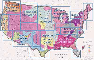
Map of Native American groupsIn Renaissance times, Europeans were not the only ones accomplishing great things. No one can deny the beauty of Michelangelo's brushwork or the brilliance of Shakespeare's verse. But societies elsewhere also flourished. As the modern world turned 1600, it seems as though each corner of the globe had its own "renaissance." The Native American societies of North America were no different. They had diverse cultures and languages, much like Europe.
When the British staked their claim to the east coast of the modern United States, they could not have dreamed of the complexity of the peoples they were soon to encounter.
There are between 140 and 160 different AMERICAN INDIAN TRIBES. There is no single Native American language. It would be as difficult for the Mohawk Indians of the East to converse with Zuni Indians of the West as it would be for Germans to converse with Turks.

Before Europeans arrived in North America, Native peoples inhabited every region. This map shows Native American tribes, culture areas, and linguistic stocks.
Twenty-seven states derive names from Indian languages. Native Americans turned wild plants such as corn, potatoes, pumpkin, yams, and lima beans into farm crops for human consumption. More than half of modern American farm products were grown by Native Americans before British colonization.
Medicine was not an unknown science in the Western Hemisphere. Most natural herbs used for medicinal purposes in the modern world had also been used by Native Americans before European contact. Archaeologists have learned that North American Indians made salt by evaporation and mined a great many minerals including copper, lead, and coal.
Despite myths to the contrary, not all Native Americans were peaceful. Like Europe, the American continent faced tribal warfare that sometimes led to human and cultural destruction.
In short, there is no simple way to tell the tale of a continent that had been peopled by diverse communities for thousands of years. Their tales are as complex as any others, their cultures as rich, their knowledge as deep. British contact did not mark the replacement of established cultures by a better way of life, but rather the beginning of a new civilization based on a blend of diverse folkways.
An examination of three groups — Anasazi, Iroquois, and Algonkian — serves as a beginning to learning about the American world that once was.
As you read this section, keep in mind the following questions:
  1. How did European explorers respond to the language, clothing, customs, dwellings, and food of the Native American peoples?
  2. How did the Native Americans respond to the language, clothing, and customs of the explorers?
  3. What are some of the difficulties in trying to understand someone from a different culture?
  4. Why was it difficult for European explorers of the 15th and 16th centuries to understand the diversity of the native peoples who lived in the Americas?
  5. How do historians and archaeologists know what the explorers experienced? How do they know what the Native American peoples experienced?
  6. What do you want to know about the Americas prior to the era of European exploration? How can you find out?

The Mayan History

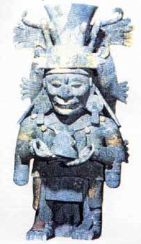
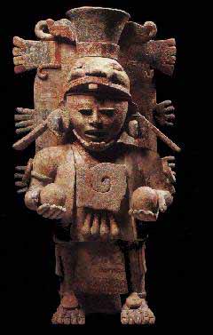
The Maya are probably the best-known of the classical civilizations of Mesoamerica. Originating in the Yucatan around 2600 B.C., they rose to prominence around A.D. 250 in present-day southern Mexico, Guatemala, western Honduras, El Salvador, and northern Belize.
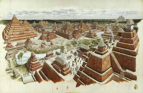
Building on the inherited inventions and ideas of earlier civilizations such as the Olmec, the Mayans developed astronomy, calendrical systems and hieroglyphic writing. The Mayans were noted as well for elaborate and highly decorated ceremonial architecture, including temple-pyramids, palaces and observatories, all built without metal tools. They were also skilled farmers, clearing large sections of tropical rain forest and, where groundwater was scarce, building sizable underground reservoirs for the storage of rainwater. The Mayans were equally skilled as weavers and potters, and cleared routes through jungles and swamps to foster extensive trade networks with distant peoples.
Many people believe that the ancestors of the Mayans crossed the Bering Strait at least 20,000 years ago. They were nomadic hunter-gatherers. Evidence of settled habitation in Mexico is found in the Archaic period 5000-1500 BC - corn cultivation, basic pottery and stone tools.
The first true civilization was established with the rise of the Olmecs in the Pre-Classic period 1500 BC -300 AD. The Olmecs settled on the Gulf Coast, and little is known about them.
The Mayans are regarded as the inventors of many aspects of Meso-American cultures including the first calendar and hieroglyphic writing in the Western hemisphere. Archeologists have not settled the relationship between the Olmecs and the Mayans, and it is a mystery whether the Mayans were their descendants, trading partners, or had another relationship. It is agreed that the Mayans developed a complex calendar and the most elaborate form of hieroglyphics in America, both based on the Olmec's versions.

Mayans seem to have entered Yucatan from the west. As usual with ancient nations, it is difficult in the beginning to separate myth from history, their earliest mentioned leader and deified hero, Itzamn‡, being considered to be simply a sun-god common to the Mayan civilization. He is represented as having led the first migration from the Far East, beyond the ocean, along a pathway miraculously opened through the waters.

The second migration, which seems to have been historic, was led from the west by Kukulcan, a miraculous priest and teacher, who became the founder of the Mayan kingdom and civilization. Fairly good authority, based upon study of the Mayans chronicles and calendar, places this beginning near the close of the second century of the Christian Era.
Under Kukulcan the people were divided into four tribes, ruled by as many kingly families: the Cocom, Tutul-xiu, Itz‡ and Chele.
To the first family belonged Kukulcan himself, who established his residence at Mayanspan, which thus became the capital of the whole nation. The Tutul-xiu held vassal rule at Uxmal, the Itz‡ at Chichen-Itz‡, and the ChelŽ at Izamal.
To the Chele was appointed the hereditary high priesthood, and their city became the sacred city of the Mayans. Each provincial king was obliged to spend a part of each year with the monarch at Mayapan. This condition continued down to about the eleventh century, when, as the result of a successful revolt of the provincial kings, Mayapan was destroyed, and the supreme rule passed to the Tutul-xiu at Uxmal.
Later on Mayapan was rebuilt and was again the capital of the nation until about the middle of the fifteenth century, when, in consequence of a general revolt against the reigning dynasty, it was finally destroyed, and the monarchy was split up into a number of independent petty states, of which eighteen existed on the peninsula at the arrival of the Spaniards.
In consequence of this civil war a part of the Itz‡ emigrated south to Lake PetŽn, in Guatemala, where they established a kingdom with their capital and sacred city of Flores Island in the lake.


Mayan Classic Period - 300-900 AD

Most artistic and cultural achievement came about during the Classic period 300 - 900 AD. The Mayans developed a complex, hierarchical society divided into classes and professions. Centralized governments, headed by a king, ruled territories with clearly defined boundaries. These borders changed as the various states lost and gained control over territory. Mayansn centers flourished in Mexico, Guatemala, Belize, Honduras, and El Salvador. The major cities of the Classic period were Tikal (Guatemala), Palenque and Yaxchil‡n (Chiapas, Mexico), Cop‡n and Quirigua (Honduras). For most of this period, the majority of the Mayans population lived in the central lowlands of Mexico and Belize.
The Northern Yucatan (where present day Cancun is located) was sparsely populated for most of the Classic period with only a few cities such as Dzibilchaltœn (near MŽrida) and Xpuhil, Bec‡n and Chicann‡ (near Chetumal). During the 9th century the population centers of the central lowlands declined significantly. This decline was very rapid and is attributed to famine, drought, breakdowns in trade, and political fragmentation. Fragmentation from large states into smaller city-states focused resources on rivalries between cities including not just wars, but competitions of architecture and art between rival cities. As the cities in the lowlands declined, urban centers sprung up in the Northern Yucat‡n, including Uxmal (near MŽrida).
Anthropologists used to contrast the "peaceful" Mayans with the bloodthirsty Aztecs of central Mexico. Although human sacrifice was not as important to the Mayans as to the Aztec, blood sacrifice played a major role in their religion. Individuals offered up their blood, but not necessarily their lives, to the gods through painful methods using sharp instruments such as sting-ray spines or performed ritualistic self mutilation. It is probable that people of all classes shed their blood during religious rites. The king's blood sacrifice was the most valuable and took place more frequently. The Mayans were warlike and raided their neighbors for land, citizens, and captives. Some captives were subjected to the double sacrifice where the victims heart was torn out for the sun and head cut off to pour blood out for the earth.
The Mayansn civilization was the height of pre-Columbian culture. They made significant discoveries in science, including the use of the zero in mathematics. Their writing was the only in America capable of expressing all types of thought. Glyphs either represent syllables or whole concepts and were written on long strips of paper or carved and painted on stone. They are arranged to be red from left to right and top to bottom in pairs of columns. The Mayansn calendar begins around 3114 BC, before Mayans culture existed, and could measure time well into the future. They wrote detailed histories and used their calendar to predict the future and astrological events. Fray Diego de Landa, second bishop of the Yucat‡n ordered a mass destruction of Mayansn books in 1562 and only three survived.


Post Classic Period - 1000 - 1500 AD - Growth and Ruin

After the Classic period, the Mayans migrated to the Yucat‡n peninsula. There they developed their own character, although their accomplishments and artwork are not considered as impressive as the Classic Mayans. Most of the ruins you can see South of Cancun are from this time period and are definitely worth a visit.
Chichen Itza (near Valladolid), Uxmal (near Merida) and Mayansp‡n (west of Chichen Itza) were the three most important cities during the Post Classic period. They lived in relative peace from around 1000 - 1100 AD when Mayansp‡n overthrew the confederation and ruled for over 200 years. In 1441 the Mayans who had previously ruled Uxmal destroyed the city of Mayansp‡n and founded a new city at Mani. Wars were fought between rival Mayansn groups over the territory until the region was conquered by the Spanish.

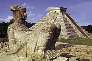
Chichen Itza was first populated between 500 and 900 AD by Mayans and for some reason abandoned around 900, the city was then resettled 100 years later and subsequently invaded by Toltecs from the North. There are numerous reliefs of both Mayan gods including Chac and the Toltec gods including Quetzalcoatl.
For some reason the city was abandoned around 1300. If the Spanish did not make it a policy to kill all of the Mayan priests and burn books when they arrived in Mexico, we would all have a few more answers.


Post Columbian Period - Conquest and Rebellion (1500 AD)

On his second voyage Columbus heard of Yucatan as a distant country of clothed men. On his fifth voyage (1503-04) he encountered, south-west of Cuba, a canoe-load of Indians with cotton clothing for barter, who said that they came from the ancient Mayan civilization.
In 1506 Pinzon sighted the coast, and in 1511 twenty men under Valdivia were wrecked on the shores of the sacred island of Cozumel, several being captured and sacrificed to the idols.
The Spanish colonization of the islands of Hispaniola and Cuba allowed them to launch exploratory forays around the Caribbean. C—rdoba discovered Isla Mujeres in 1517 and sailed down the Yucat‡n Gulf coast to were he suffered heavy losses at the hands of the Mayans. CortŽs set sail in 1519 and landed in Veracruz. He conquered the Aztecs in a year, but it took another 20 years to conquer the Yucat‡n. In 1526 Francisco Montejo set out to conquer the Yucatan.
The Mayans fought the invaders for 20 years, but eventually succumbed. The Mayans were slaughtered during the battles with the Spaniards, but imported European diseases decimated the population. The Mayans were moved into villages and paid heavy taxes to the Spanish government. There were periodic rebellions against the Spanish.
The Yucatan Mayans launched a major uprising starting in July 1847 called the Caste War. The Spanish were distracted by the war between the US and Mexico and nearly lost the peninsula. The Mayans attacked Spanish villages armed by English settlers from Belize and with guns distributed to defend Yucat‡n's secession in 1846. They regained 90% of their lands and held all of the Yucat‡n except Campeche and Merida.
At the height of their revolutionary success, the Mayans inexplicably withdrew to their villages - reputedly to plant corn for the season. The war with the US ended in 1848 and reinforcements were sent to the Yucat‡n, where they drove the Mayans back to Chan Santa Cruz. The Mayans resisted for several years, but disease and weapons shortages forced them to surrender in 1901.
After 50 years of independence, their lands became federal territory. In reality, the Southern and Eastern half of the peninsula remained a virtual no man's land to outsiders where the Mayans lived almost as they pleased. This changed in the late 1960s when coastal development began.
Father Alonso Gonzalez, who accompanied this expedition, found opportunity at one landing to explore a temple, and bring off some of the sacred images and gold ornaments. In 1518 a strong expedition under Juan de Grijalva, from Cuba, landed near Cozumel and took formal possession for Spain.
For Father Juan Diaz, who on this occasion celebrated Mass upon the summit of one of the heathen temples, the honour is also claimed of having afterwards been the first to celebrate mass in the City of Mexico.
Near Cozumel, also, was rescued the young monk Aguilar, one of the two survivors of Valdivia's party, who, though naked to the breech-cloth, still carried his Breviary in a pouch. Proceeding northwards, Grijaba made the entire circuit of the peninsula before returning, having had another desperate engagement with the Mayans near Campeche.
After the conquest of Mexico in 1521, Francisco de Montejo, under commission as Governor of Yucatan, landed (1527) to effect the conquest of the country, but met with such desperate resistance that after eight years of incessant fighting every Spaniard had been driven out. In 1540, after two more years of the same desperate warfare, his son Francisco established the first Spanish settlement at Campeche.
In the next year, in a bloody battle at Tihoo, he completely broke the power of Mayans resistance, and a few months later (Jan., 1542) founded on the site of the ruined city the new capital, MŽrida. In 1546, however, there was a general revolt, and it was not until a year later that the conquest was assured.
In the original commission to Montejo it had been expressly stipulated that missionaries should accompany all his expeditions. This, however, he had neglected to attend to, and in 1531 (or 1534), by special order, Father Jacobo de Testera and four others were sent to join the Spanish camp near Campeche.
They met a kindly welcome from the Indians, who came with their children to be instructed, and thus the conquest of the country might have been effected through spiritual agencies but for the outrages committed by a band of Spanish outlaws, in consequence of which the priests were forced to withdraw.
In 1537 five more missionaries arrived and met the same willing reception, remaining about two years in spite of the war still in progress. About 1545 a large number of missionaries were sent over from Spain. Several of these - apparently nine, all Franciscans - under the direction of Father Luis de Villalpando, were assigned to Yucatan.
Landing at Campeche, the governor explained their purpose to the chiefs, the convent of St. Francis was dedicated on its present site, and translations were begun into the native language. The first baptized convert was the chief of Campeche, who learned Spanish and thereafter acted as interpreter for the priests.
Here, as elsewhere, the missionaries were the champions of the rights of the Indians. In consequence of their repeated protests a royal edict was issued, in 1549, prohibiting Indian slavery in the province, while promising compensation to the slave owners.
As in other cases, local opposition defeated the purpose of this law; but the agitation went on, and in 1551 another royal edict liberated 150,000 male Indian slaves, with their families, throughout Mexico.
In 1557 and 1558 the Crown intervened to restrain the tyranny of the native chiefs. Within a very short time Father Villalpando had at his mission station at MŽrida over a thousand converts, including several chiefs.
He himself, with Father Malchior de Benavente, then set out, barefoot, for the city of Mani in the mountains farther south, where their success was so great that two thousand converts were soon engaged in building them a church and dwelling. All went well until they began to plead with the chiefs to release their vassals from certain hard conditions, when the chiefs resolved to burn them at the altar.
On the appointed night the chiefs and their retainers approached the church with this design, but were awed from their purpose on finding the two priests, who had been warned by an Indian boy, calmly praying before the crucifix. After remaining all night in prayer, the fathers were fortunately rescued by a Spanish detachment which, almost miraculously, chanced to pass that way.
Twenty-seven of the conspirators were afterwards seized and condemned to death, but were all saved by the interposition of Villalpando.
In 1548-49 other missionaries arrived from Spain, Villalpando was made custodian of the province, and a convent was erected near the site of his chapel at Mani. The Yucatan field having been assigned to the Franciscans, all the missionary work among the Mayans was done by priests of that order.
In 1561 Yucatan was made a diocese with its see at MŽrida.
1562 - the famous Diego de Landa, Franciscan provincial, and afterwards bishop (1573-79), becoming aware that the natives throughout the peninsula still secretly cherished their ancient rites, instituted an investigation, which he conducted with such cruelties of torture and death that the proceedings were stopped by order of Bishop Toral Franciscan provincial of Mexico, immediately upon his arrival, during the same summer, to occupy the See of MŽrida.
Before this could be done, however, there had been destroyed, as is asserted, two million sacred images and hundreds of hieroglyphic manuscripts - practically the whole of the voluminous native Mayans literature. As late as 1586 a royal edict was issued for the suppression of idolatry.
In 1575-77 a terrible visitation of a mysterious disease, called matlalzahuatl, which attacked only the Indians, swept over Southern Mexico and Yucatan, destroying, as was estimated, over two million lives. This was its fourth appearance since the conquest.
At its close it was estimated that the whole Indian population of Mexico had been reduced to about 1,700,000 souls. In 1583 and 1597 there were local revolts under chiefs of the ancient Cocom royal family. By this latter date it was estimated that the native population of Mexico had declined by three-fourths since the discovery, through massacre, famine, disease, and oppression.
Up to 1593 over 150 Franciscan monks had been engaged in missionary work in Yucatan.
The Mayans history of the seventeenth century is chiefly one of revolutions, viz., 1610-33, 1636-44, 1653, 1669, 1670, and about 1675.
Of all these, that of 1636-44 was the most extensive and serious, resulting in a temporary revival of the old heathen rites. In 1697 the island capital of the Itz‡, in Lake PetŽn, Guatemala, was stormed by Governor Mart’n de Ursua, and with it fell the last stronghold of the independent Mayans. Here, also, the manuscripts discovered were destroyed.
In 1728 Bishop Juan Gomez Parada died, beloved by the Indians for the laws which he had procured mitigating the harshness of their servitude. The reimposition of the former hard conditions brought about another revolt in 1761, led by the chief Jacinto Canek, and ending, as usual, in the defeat of the Indians, the destruction of their chief stronghold, and the death of their leader under horrible torture.
In 1847, taking advantage of the Government's difficulties with the United States, and urged on by their "unappeasable hatred toward their ruler from the earliest time of the Spanish conquest", the Mayans again broke out in general rebellion, with the declared purpose of driving all the whites, half-breeds and negroes from the peninsula, in which they were so far successful that all the fugitives who escaped the wholesale massacres fled to the coast, whence most of them were taken off by ships from Cuba. Arms and ammunition for the rising were freely supplied to the Indians by the British traders of Belize.
In 1851 the rebel Mayans established their headquarters at Chan-Santa-Cruz in the eastern part of the peninsula. In 1853 it seemed as if a temporary understanding had been reached, but next year hostilities began again. Two expeditions against the Mayans stronghold were repulsed, Valladolid was besieged by the Indians, Yecax taken, and more than two thousand whites massacred.
In 1860 the Mexican Colonel Acereto, with 3,000 men occupied Chan-Santa-Cruz, but was finally compelled to retire with the loss of 1,500 men killed, and to abandon his wounded - who were all butchered - as well as his artillery and supplies and all but a few hundred stand of small arms.
The Indians burned and ravaged in every direction, nineteen flourishing towns being entirely wiped out, and the population in three districts being reduced from 97,000 to 35,000. The war of extermination continued, with savage atrocities, through 1864, when it gradually wore itself out, leaving the Indians still unsubdued and well supplied with arms and munitions of war from Belize.
1868 - fighting broke out again in resistance to the Juarez government.
1871 - a Mexican force again occupied Chan-Santa-Cruz, but retired without producing any permanent result.
1901 - after long preparation, a strong Mexican force invaded the territory of the independent Mayans both by land and sea, stormed Chan-Santa-Cruz and, after determined resistance, drove the defenders into the swamps.
1910 - Mexican troops put down a serious rising in the northern part of the peninsula.


Modern Mayans

Mayans are around today
In spite of the invasion of foreign tourism, Mayan culture has remained amazingly intact. Many of the Yucatan Mayans whose ancestors were hunters, chicle farmers and fisherman now work in hotels and other tourist related businesses. More than 350,000 Mayans living in the Yucatan speak Yukatek Mayans and most speak Spanish as a second language, primarily learned in school.
The clothing worn is as it was in the past. It is relatively easy to determine the village in which the clothing was made by the the type of embroidery, color, design and shape.
Mayans women can be seen wearing huipils, simple cotton dresses decorated with embroidery. The designs in their embroidery and weaving can be traced back to pre-Columbian times.
Although Mayans in other parts of Central America choose to limit contact with outside influences, Mayans working in the tourist industry are generally open to conversation with polite strangers and if asked will teach you a Mayan phrase or two.
In the Indian communities, as it was with their Mayan ancestors, the basic staple diet is corn.
Mayan dialects of Qhuche, Cakchiquel, Kekchi, and Mam are still spoken today, although the majority of Indians also speak Spanish.

Maya Civilization Wikipedia


The Maya were resourceful in harnessing energy, creating amazingly sophisticated works of art and engineering and sustaining a civilization for approximately 1,500 years. It has been shown that the Maya had attributes of the supernatural, and were masters of their environment. Their secret wisdom remains unknown, some people attributing it to extraterrestrials races, whose space ships are seen to this very day in Central and South America.

As with ancient Egyptian Pharaohs, Mayan rulers filled vast cities with sky high pyramids, ornate and lavish palaces personifying the power of the great kings and their connections to the gods, and astronomical observatories which helped them created their calendars and plan their lives.
The cause of the Mayan collapse came over decades with no one quite sure what happened. There is no one single explanation for this implosion, but some scholars seem to believe that environmental catastropy lead to a full blown meltdown - lack of food and polluted water which produced malnutrition and disease.
As with all civilizations, we discover that their Gods - like those some people worship today our Gods - did not help - as they do not exist - only our own consciousness to guide us in the wastelands of realities.
Mayan archaeology is coming into it's Golden Age with the help of satellite imagery and photography. There are innumerable Mayan cities, temples, and settlements still to be discovered. We have learned that the Maya were an innovative, creative, and majestic people with their own particular taste for violence. The allure of the Maya is coming to the fore. Like the mystique of Egypt, people are drawn to the land of the Maya, each year. There is something they are guided to find, perhaps linked to major planetary grid points that awaken consciousness.
Could other attractions to the land of the Maya include:

  • Mayan architecture with its serene palaces and temples
  • the intricacies of hieroglyphs and art in a complex writing system
  • the astounded comprehension of astronomy and mathematics with a concept of zero unparalleled in antiquity
  • is it simply because these remarkable people carved magnificent cities, not just villages and towns, right out of some of the most inhospitable landscape in the entire world? In the rain forest between Honduras and the Yucatan, there are literally thousands of Maya sites that remain untouched. In Palanque alone there are approximately 1,550 buildings that lie unexcavated with endless archaeological treasures yet to be found.